
Flights operating under visual flight rules (VFR) flying into instrument meteorological conditions (IMC) remains a prominent safety issue, with the Australian Transport Safety Bureau recording 111 occurrences over the last 10 years, investigating 18 serious incidents and accidents.
A decade after publishing 178 seconds to live, we look back at our cover story from 2006 and the safety advice still relevant today.
From Flight Safety Australia January-February 2006…
It’s an all too common scenario: a VFR pilot flies into IMC and needs help.
On average, Australian air traffic controllers are called upon once every 10 days to assist a pilot in deteriorating weather. Of the reported occurrences, 60 per cent are above cloud and can’t get down. The remainder are either in deteriorating weather, in cloud or have reduced visibility due to smoke or haze.
It is a dangerous situation. American research shows that 76 per cent of VFR into IMC accidents involve a fatality. The dangers of flying VFR into IMC have been recognised for a long time. Yet VFR pilots still fly into deteriorating weather and IMC.
Some of these pilots may simply underestimate the danger and overestimate their ability to cope with flight in reduced visibility. The pilots of the 24 fatal aircraft accidents involving continued flight into IMC in Australia over the 10 years from 1992 to 2002 probably thought the same thing. Fifty-four lives were lost in these accidents.
At some stage in your flying you will encounter bad weather—unless you only fly on perfect weather days.
Spatial disorientation is the big danger. And it can happen a lot faster than you might think—just 178 seconds on average, about the length of a commercial on TV. That estimate is based on studies in the 1990s by aviation researchers at the University of Illinois. They took 20 VFR pilots and got them to fly into IMC in specially programmed flight simulators.
All of the pilots in the study went into graveyard spirals that would have ended in uncontrolled flight into terrain or rollercoaster-like oscillations that became so intense that they would have resulted in structural failure of the aircraft.
In repeated tests on the simulator the result was the same—all pilots lost control of the aircraft. The outcome differed only in the time required before control was lost which ranged from just 20 seconds to 480 seconds.
A close look at one VFR into IMC incident illustrates the dangers.
In 1999, a pilot was conducting a visual flight rules (VFR) flight from Walgett to an airstrip near Merriwa. The Piper Archer had departed from Walgett earlier in the day, but returned a short time later when it was reported that weather at the destination was not suitable for VFR flight.
However, the pilot felt under pressure to complete the flight that day. He continued to monitor the weather by telephoning for weather reports from an automatic Bureau of Meteorology outlet and by contacting a friend near the destination airfield.
The aircraft departed again at 1415. But the pilot never reached Merriwa.
The aircraft’s wreckage was located two days later on top of a ridge, 3880 ft above mean sea level (AMSL) slightly to the left of the direct track between Walgett and Merriwa.
The Australian Transport Safety Board (ATSB) investigation found that the Piper Archer collided with trees during a right turn, at a rate of descent of about 2500 ft/min.
A post impact fire consumed the cabin and fuselage immediately behind the cabin. The pilot and passenger escaped the wreckage; however, the pilot died from his injuries before rescuers could get to the accident site.
The pilot held a private pilot licence for aeroplanes and a commercial helicopter licence, together with a valid medical certificate. He did not hold an instrument rating and the aircraft was not approved for IMC.
Reports at the time of the accident indicated that the cloud base was 3600 ft AMSL, and that cloud was covering the ridge where the wreckage was found. The weather over lower terrain to the southwest of the accident site was suitable for VFR flight.
Once the aircraft entered cloud, the pilot was no longer able to rely on external visual references, and most likely became spatially disoriented.
Investigators noted that the pressure the pilot felt to complete the flight might have influenced him into choosing the shortest direct route over high terrain, with associated poor visibility, rather than the longer route further to the southwest, where clearer conditions prevailed.
Decisions, decisions
Just how different decision-making patterns affect safety was the subject of a recent ATSB report.
Three weather-related decision-making behaviours were compared: VFR pilots flying into IMC; a weather-related precautionary landing; and significant weather avoidance action.
The results suggest that the mid-point of the flight can be a ‘psychological turning point’ for pilots, regardless of the flight distance involved.
The VFR into IMC group had the greatest risk of a fatality or serious injury, while the ‘precautionary landing’ group had the greatest risk of some form of aircraft damage.
The chance of a VFR into IMC encounter increased as the flight progressed, until it reached a peak during the final 20 per cent of the flight distance. The results highlight the danger of pilots ‘pressing on’ to reach their destination.
A VFR pilot may exhibit a range of behaviours when faced with adverse weather. For example, at the first hint that conditions are deteriorating, a pilot may decide to immediately return to the point of departure.
At the other extreme, a pilot may ‘press on’ into deteriorating weather, either unable or unwilling to see the increasing danger of their actions, until the aircraft suddenly enters IMC.
A more typical scenario might involve a pilot who, in response to deteriorating conditions, initially continues the flight as planned, but later decides to return, divert, or perhaps even carry out a precautionary landing.
Chance can play a big part in the outcome as the following two accident case histories illustrate:
In case 1, the aircraft was on a private flight from Shepparton to Moorabbin with the pilot and three passengers on board. Before departing from Shepparton, the pilot had obtained an enroute weather forecast that indicated that VFR flight via the Kilmore gap was possible but that conditions were likely to be marginal.
On departure from Shepparton, there was scattered cloud at 2500 ft with a ceiling of approximately 4000 ft. Visibility was about eight km, with occasional rain showers.
As the flight approached Mangalore, the hills to the east and southwest were shrouded in low stratus. Abeam Seymour, the weather ahead appeared to be closing in so the pilot began a left turn onto a reciprocal heading for Mangalore.
However, the weather had closed in from behind, and soon after completing the turn the aircraft was enveloped in cloud.
The pilot contacted Melbourne ATC and reported that he was in cloud with nil visibility. ATC advised him to concentrate on keeping the wings level, and provided radar vectors to ensure that the aircraft remained clear of high terrain in the vicinity.
Abeam Mangalore the aircraft broke free of cloud and the pilot was able to resume navigation. The flight continued to Shepparton and a safe landing.
This pilot emerged unscathed from a VFR into IMC incident because—luckily—advice and guidance were at hand.
In contrast, the pilot involved in the next accident, while initially slow to recognise deteriorating weather, made a wise decision to carry out a precautionary landing.
In spite of this, the aircraft was destroyed and the pilot and one of his passengers were injured.
The planned flight was from Bendigo to Albury. The area forecast indicated that the weather enroute would be okay for VFR flight. A cold front was moving slowly through the region from the southwest, but was not forecast to reach the area of the planned route until after the flight. The pilot did not hold an instrument rating but had completed three hours of instrument flight training.
The aircraft departed Bendigo at 11 am with the pilot, his wife, and their two children on board. It soon became clear that the front was moving much more quickly than forecast and that the weather along the planned route could deteriorate below that required for VFR flight. The pilot decided to return to Bendigo and told ATC of his intentions.
A short time later the pilot again contacted ATC and advised that the weather had deteriorated further and that he was going to carry out a precautionary landing in the Rushworth area.
The pilot identified a suitable landing area and carried out a low speed pass to confirm the area was free of obstacles. He configured the aircraft for a precautionary landing and made a slow-speed approach to the field.
Just after touchdown the nose gear hit the bank of a ditch that was hidden by reeds and long grass. The nose gear was sheared off, and the aircraft continued for some distance before it overturned and came to rest.
The pilot and the front-seat passenger were restrained by their lap-sash seat belts, but the pilot suffered a fracture to his left arm. One of the passengers in the rear of the aircraft received minor injuries.
What happens when you enter cloud?
Our normal environment is with two feet planted firmly on the earth, clear vision of our surroundings, gravity allowing us to feel weight/pressure on our feet (with a force of 1 g), and our inner ears providing our sense of balance.
Orientation is achieved with 80 per cent of the input to your brain coming from your eyes (external visual references) and 20 per cent split between your inner ear and proprioceptive system (seat of the pants or what you feel).
When you are flying you are operating in an unnatural environment that can result in different forces.
Usually it is easy to orient yourself in VFR flight. You have visual reference to a horizon outside the aircraft, and in steady flight you only have a force of 1 g acting on you. Even pulling 2 g in a steep turn is usually not a problem as long as you can see a horizon to maintain orientation.
But when a VFR pilot enters cloud, the horizon disappears. Suddenly, 80 per cent of the input you need for orientation is lost. Worse, if your flight attitude changes, or you make any manoeuvre that results in forces of more than 1 g, your sense of balance will also change.
Spatial illusions and disorientation are created when the fluid of the inner ear responds to acceleration, deceleration, pitch, roll and yaw.
It is very easy to find yourself in a gradual turn once you have lost the horizon.
Your inner ears will simply not detect the change.
Even after a minor distraction in the cockpit, you can find that when you look back at the artificial horizon that there has been a slow, 10 or 15-degree bank angle introduced.
You make control inputs to correct the turn. But without a view of the horizon you will be relying on your sense of balance provided by your inner ears. e problem is that the acceleration forces affect the fluids in your inner ears resulting in a sensation of turning in the opposite direction.
To overcome this illusion you might make a correction back to the original position. While this may feel better to you, the original turn has been reintroduced with the airspeed increasing and the altimeter unwinding rapidly.
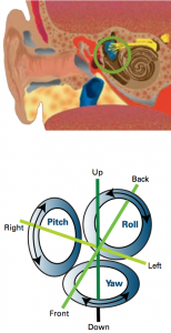
canals in the inner ear is aligned along
a different axis of rotation and contains
a small tuft of sensory hairs (above
circled). Orientation illusions can
occur when these hairs are affected by
acceleration.
The illusions can be so strong that many pilots will disregard their instruments, certain that they’re wrong.
There is a simple way to demonstrate what it feels like to experience a slight disorientation or dizziness similar to the illusions that may happen in a cockpit in cloud. Sit on a swivel once chair and tuck you feet under the seat of the chair. Close your eyes and place your head forward so your chin touches your chest. Hold onto the seat so you don’t fall off and get someone to spin you around on the chair for 3 or 4 rotations (it doesn’t have to be very fast).
Then lift your head up straight and open your eyes. You will feel a slight dizziness as the movement of the fluid in the inner ear was moved into another rotational plane when you moved your head. This is different to what your eyes were telling you.
If you are VFR and you and yourself in IMC you need to ignore your senses, and follow your instruments. Seek help from ATC if you can. And try to remain calm.
Some general principles of instrument flying need to be understood and followed:
- Trust the instruments and believe what they are telling you.
- Maintain a scan of the instruments.
- Do not dwell on one instrument for too long, and check the attitude indicator after you check any other instrument.
- Use smooth and gentle control inputs to get the aircraft to do what you want.
One of the keys to avoiding a VFR into IMC incident is to be able to recognise deterioration in the weather while there is still time to make a safe diversion. This is often easier said than done, but there is evidence that in-flight, weather-related decision-making can be practised and learned.
Research by the US Federal Aviation Administration has found that experienced pilots generally use the following indicators to assess in-flight weather changes:
- Lowering cloud base.
- Rising terrain.
- Darkening clouds.
- Increasing cloud cover.
- Reducing visibility.
- Rain showers.
- Changes in wind direction and speed.
A change in three or more indicators was sufficient for the experienced pilot to initiate a diversion to an alternate or a return to the departure aerodrome.
You should monitor the weather behind your aircraft. There is no point deciding to turn back to find that the weather behind the aircraft is as bad as it is in front—or worse.
Always give yourself time to make informed decisions. If the weather appears to be getting worse, slow the aircraft down (use flaps and lower the undercarriage). The slower speed will usually improve your forward visibility and give you more decision making time. It will also reduce your turning radius if you have to manoeuvre in a tight space.
The safest thing to do is to cancel a flight if the conditions look like they might become marginal. But it can be a difficult decision because you might have a lot of time and effort invested in the flight, and there may be friends and family counting on you.
Remember, your primary responsibility is your safety and the safety of your passengers.
Preparation: The key, of course, is to avoid deteriorating weather or IMC in the planning phase. Thorough weather planning and an extensive understanding of weather forecasts and meteorological conditions help pilots determine whether the weather is acceptable for VFR flight.
There are many sources of information to help you do this apart from the standard NAIPS (or AVFAX if you still use it) pre-flight information.
The Bureau of Meteorology website has long-term forecasts by region.
While these are not aviation specific, you can use them to get an idea of the weather several days ahead. Severe thunderstorm warnings are also available.
The weather on the TV usually gives a satellite image and a surface chart. Get to know what they mean and use them to check the weather around you even when not flying to give you an indication of how frontal passages and cloud bands evolve.
However, when you do commit to going flying make sure you get the relevant aviation forecasts you need from NAIPS and update them through FLIGHTWATCH.
The AIP has a weather decode and MET section to assist you. The on-duty meteorologist will go through any queries you might have with the forecast.
You can also call ahead to your destination to find out actual weather or check with ATC to hear from pilots flying along the route.
The Bureau of Meteorology aviation section is an excellent resource for pilots and contains explanation of weather phenomena, up-to-date forecasts and many tips to aid safer flying. The Bureau also encourages pilots to ring the weather briefing service to discuss forecasts with experienced meteorologists.
When you are planning to take others on a private flight, make sure they understand the importance of the weather conditions, and tell them that you will cancel plans if the weather is not suitable. If someone has to be home by a certain time, make sure they understand this might not be possible.
Preparation is the key. Have the current AIP, ERSA, maps and charts to ensure you have the latest information about aerodromes, NAVAIDS and facilities available, including ATC frequencies.
Learn how to use NAIPS to obtain weather and NOTAM information, and always submit a flight plan with a SARTIME through NAIPS. Use the BOM elaborative briefings. Use ATC flight following services enroute. Call FLIGHTWATCH for updates of weather reports. And remember to always set the QNH within 100 nm of the position of your aircraft to ensure you are flying an accurate height.
It all comes down to thorough preparation, alternate plans and timely decision-making. And decisions have to be constantly reassessed based on the current situation—looking and planning ahead is essential. Problems occur when pilots fail to make a decision. It’s vital that you constantly consider your options and that you are prepared to act swiftly.
Think could I get through there—have I got an escape route? It’s okay to turn around. It’s okay to consider that I won’t make my destination.
It comes down to thorough preparation, a range of alternate plans and timely decision-making.
Thunderstorms
Whether you are a VFR or IFR pilot, thunderstorms represent the most dangerous of commonly encountered weather phenomena. A new advisory circular from the Federal Aviation Administration gives some pointers for IFR pilots.
A thunderstorm packs just about every weather hazard known to aviation into one vicious bundle. The most hazardous is a narrow band of active thunderstorms known as the squall line. Often a squall line develops on or ahead of a cold front in moist, unstable air, but it may develop in unstable air far from any front. The line may be too long to detour around easily and too wide and severe to penetrate.
It often contains steady-state thunderstorms and presents the single most intense weather hazard to aircraft. It usually forms rapidly, generally reaching maximum intensity during the late afternoon and the first few hours of darkness.
The most violent thunderstorms draw air into their cloud bases with great vigour. If the incoming air has any initial rotating motion, it often forms an extremely concentrated vortex from the surface well into the cloud.
Meteorologists have estimated that wind in such a vortex can exceed 200 kt; pressure inside the vortex is quite low. The strong winds gather dust and debris and the low pressure generates a funnel shaped cloud extending downward from the cumulonimbus base. If the cloud does not reach the surface, it is a “funnel cloud”; if it touches a land surface, it is a “tornado.”
Turbulence
The strongest turbulence within a thunderstorm cloud occurs with shear between updrafts and downdrafts. Outside the cloud, shear turbulence has been encountered several thousand feet above and 20 nm laterally from a severe storm.
A low level turbulent area is the shear zone associated with the gust front. Often, a ‘roll cloud’ at the leading edge of a storm marks the top of the eddies in this shear and signifies an extremely turbulent zone.
Gust fronts often move far ahead (up to 15 nm) of associated precipitation. The gust front causes a rapid and sometimes drastic change in surface wind ahead of an approaching storm.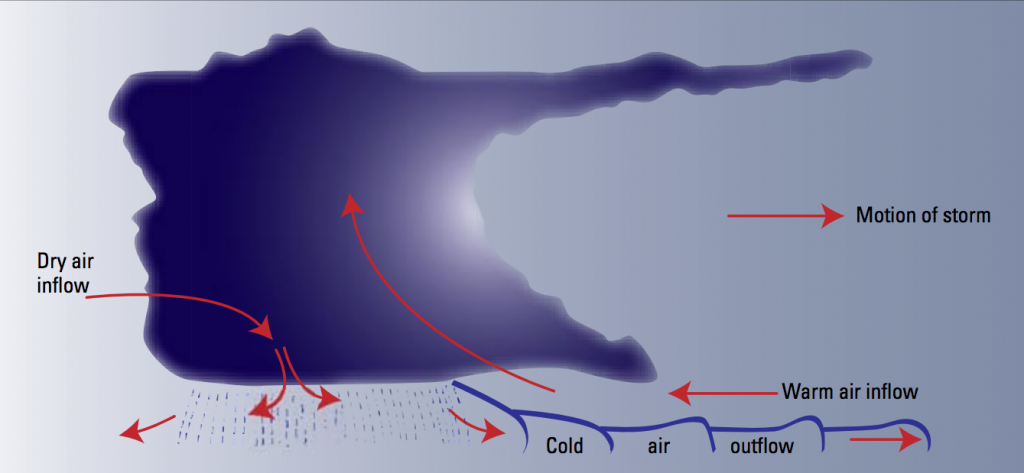
The accompanying diagram shows a schematic cross section of a thunderstorm with areas outside the cloud where turbulence may be encountered. It is almost impossible to hold a constant altitude in a thunderstorm, and manoeuvring in an attempt to do so produces greatly increased stress on the aircraft.
Stresses are least if the aircraft is held in a constant attitude and allowed to ‘ride the waves’.
Hail and ice
Updraft in a thunderstorm support abundant liquid water with relatively large droplet sizes; and when carried above the freezing level, the water becomes supercooled.
When the temperature in the upward current cools to about -15 ° C, much of the remaining water vapour will form ice crystals.
Above this level, at lower temperatures, the amount of supercooled water decreases. Supercooled water freezes on impact with an aircraft. Clear icing can occur at any altitude above the freezing level; but at high levels, icing from smaller droplets may be rime or mixed rime and clear. The abundance of large, supercooled water droplets makes clear icing very rapid between 0° C and -15° C and encounters can be frequent in a cluster of cells. Thunderstorm icing can be extremely hazardous.
Hail competes with turbulence as the greatest thunderstorm hazard to aircraft. Supercooled water drops above the freezing level begin to freeze. Once a drop has frozen, other drops latch on and freeze to it, so the hailstone grows – sometimes into a large iceball. Eventually, the hailstones fall, possibly some distance from the storm core. Hail may be encountered in clear air several miles from dark thunderstorm clouds.
As hailstones fall through air with a temperature above 0° C, they begin to melt and precipitation may reach the ground as either hail or rain, so rain at the surface does not mean the absence of hail above. You should beware of hail with any thunderstorm, especially beneath the anvil of a large cumulonimbus. Hailstones several centimetres in diameter can cause damage to an aircraft in just a few seconds.
More hazards
Ceiling and visibility also may be restricted as a result of precipitation and dust between the cloud base and the ground.
Pressure usually falls rapidly with the approach of a thunderstorm, and then rises sharply with the onset of the first gusts and the arrival of the cold downdraft and heavy rain showers, falling back to normal as the storm moves on. is cycle of pressure change can occur in just 15 minutes. If you do not receive a corrected altimeter setting, the altimeter may be more than 100 ft in error.
Thunderstorms generate lightning that can puncture the skin of an aircraft and can damage communications and electronic navigational equipment. Nearby lightning can render you momentarily blind, leaving you unable to navigate either by instruments or by visual reference. Nearby lightning can also induce permanent errors in the magnetic compass. Lightning discharges, even distant ones, can disrupt radio communications on low and medium frequencies.
Updrafts are present in many thunderstorms, particularly those in the developing stages. If the updraft velocity in the thunderstorm approaches or exceeds the terminal velocity of the falling raindrops, very high concentrations of water may occur. It is possible that these concentrations can be larger than turbine engines are designed to ingest. There is no known operational procedure that can eliminate the possibility of engine damage or flameout resulting from massive water ingestion. Although the exact mechanism of these water induced engine stalls has not been determined, technical specialists believe that thrust changes could have an adverse effect on engine stall margins during a massive water ingestion.
During an unavoidable encounter with severe storms with extreme precipitation, you should follow the severe turbulence penetration procedure in the approved aircraft flight manual and avoid thrust changes unless excessive airspeed variations occur.
Weather radar
Weather radar detects droplets of precipitation size. The strength of the radar return (echo) depends on drop size and number. The greater the number of drops, the stronger the echo; and the larger the drops, the stronger the echo.
Drop size determines echo intensity to a much greater extent than does drop number. Hailstones usually are covered with a film of water and, therefore, act as huge water droplets giving the strongest of all echoes.
Thunderstorms build and dissipate rapidly. Therefore, do not attempt to plan a course between echoes. e best use of ground radar information is to isolate general areas and coverage of echoes. You must avoid individual storms from inflight observations either by visual sighting or by airborne radar. It is better to avoid the whole thunderstorm area than to detour around individual storms, unless they are scattered.
Airborne weather avoidance radar is, as its name implies, for avoiding severe weather – not for penetrating it. Whether to fly into an area of radar echoes depends on echo intensity, spacing between the echoes, and the capabilities of you and your aircraft.
Remember that weather radar detects only precipitation drops; it does not detect turbulence. The radarscope also does not provide assurance of avoiding instrument weather from clouds and fog. Your scope may be clear between intense echoes; however, this clear area does not necessarily mean that you can fly between the storms and maintain visual sighting of them.
Above all, remember this: never regard any thunderstorm lightly, even when radar observers report the echoes are of light intensity.
Avoiding thunderstorms is the best policy.
Key operational points
Avoidance
- Don’t land or takeoff in the face of an approaching thunderstorm. A sudden gust front of low level turbulence could cause loss of control.
- Avoid by at least 20 nm any thunderstorm identified as severe or giving an intense radar echo. This is especially true under the anvil of a large cumulonimbus.
- Circumnavigate the entire area if the area has 6/10 thunderstorm coverage.
- Regard as extremely hazardous any thunderstorm with tops 35,000 ft or higher whether the top is visually sighted or determined by radar. Remember that vivid and frequent lightning indicates the probability of a severe thunderstorm.
- Even if you can see through to the other side of the storm do not attempt to fly under it. Turbulence and windshear under the storm can lead to disaster.
Inside the storm
- If you cannot avoid penetrating a thunderstorm, following are some steps to take before entering the storm:
- Tighten your safety belt, put on your shoulder harness if you have one, and secure all loose objects.
- Plan and hold your course to take you through the storm in a minimum time. Don’t turn back once you are in the thunderstorm. A straight course through the storm most likely will get you out of the hazards most quickly.
- To avoid the most critical icing, establish a penetration altitude below the freezing level or above the level of -15° C.
- Verify that pitot heat is on and turn on carburetor heat or jet engine anti-ice. Icing can be rapid at any altitude and cause almost instantaneous power failure and loss of airspeed indication.
- Establish power settings for the turbulence penetration airspeed recommended in your aircraft manual.
- Turn up cockpit lights to highest intensity to lessen temporary blindness from lightning.
- If you are using automatic pilot, disengage altitude hold mode and speed hold mode. The automatic altitude and speed controls will increase maneuvers of the aircraft thus increasing structural stress.
- If you are using airborne radar, tilt the antenna up and down occasionally. This will allow you to detect other thunderstorm activity at altitudes other than the one being flown.
- Don’t fly without airborne radar into a cloud mass containing scattered embedded thunderstorms.
- Don’t trust visual appearance to be a reliable indicator of the turbulence inside a thunderstorm.
This article was originally published in the January – February of Flight Safety Australia 2006.


These articles make for interesting reading but that’s about all. To really help reduce this and the other hazard that takes more lives than aviation by far (auto accidents) is training. Way too easy to get a car licence and way too easy to get a licence to drive a plane. During my training to UPPL a hundred yrs ago I did 5 hrs under a hood, totally inadequate seeing as I never got checked again for years til I went with a class 4 and then on to an IFR rating. Make it 10 times harder to get a plane licence with far more IMC training then you might reduce the deaths, till then we’ll read about more accidents/incidents that need not be if the authorities got tuff!
In Europe I’m looking at 104 hours of classes plus 40 hours of flight training for my PPL. I guess things have changed since 100 years ago ;)
The problem is most people get blasé and think s##t wont happen to them. Or be like me “10ft tall an bulletproof “!!! But if it can screw up Richard De Crupny with 17000 hrs. What hope does a guy with 45 hrs have?? I’ve always thought as long as you watch the instruments you’ll be right. Now I’m not so sure…….
[…] Inflight decision-making is one of the ATSB’s SafetyWatch priorities, particularly regarding pilots flying with reduced visual reference. One of the key messages of SafetyWatch is on the use of ‘personal minimums’ checklists. VFR pilots should use a checklist to help control and manage flight risks by identifying risk factors that include marginal weather conditions and only fly in environments that do not exceed their capabilities. […]
The “180-Degree Turn Experiment”.
In 1954 (!), the University of Illinois, Urbana, and AOPA joined forces to devise a curriculum which would train a noninstrument pilot to “get out of” weather conditions into which he had flown inadvertently. The “180-Degree Turn Experiment” was intended to teach pilots to keep a plane upright if caught on instruments, make good enough 180-degree turn to get back to VMC weather, or get down through cloud deck. 20 VFR-Pilots and a Beech Bonanza were chosen for this experiment. (Chief Flight Instructor: Jesse W. Stonecipher).
Many years later the FAA issued an article: “178 Seconds to Live”, FAA Aviation News, 1993, 32 (1). It was related to the 180-degree experiment: when coming out of the cloudbase upside down, you have just 178 seconds to live.