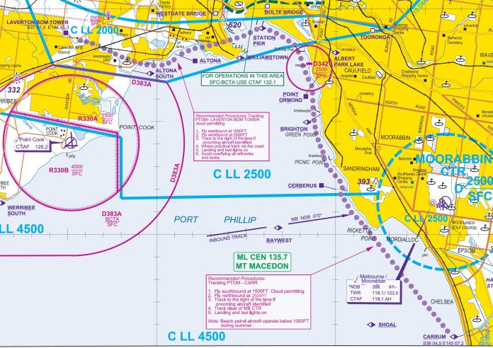
After concerns raised by industry, airspace changes that came into effect on 8 November for the Melbourne Port Philip Bay VFR route have been modified.
Class C airspace remains lowered from 2500 feet to 2000 feet under the approach and departure path for Runway 34 at Melbourne Tullamarine airport to accommodate a Category 1 ground-based augmentation system landing system (GLS) approach.
But changes made to the direction and recommended altitudes for VFR pilots flying the coastal route between the Laverton BOM Tower and Carrum, and vice versa have been superseded.
The new procedure recommends:
- Between Point Ormond and Laverton BOM tower, fly eastbound at 1500 feet and westbound at 2000 feet
- Between Point Ormond and Carrum, fly southbound at 1500 feet and northbound at 2500 feet.
The changes will take place on 28 November at 0200 AEDT. The arrangements are similar to those in place before 8 November but accommodate the new Class C lower limit.
Recently issued charts will not be updated until May, meanwhile pilots must check notams and the AIP supplement before every flight.


Amazing!! Us pilots would get crucified if we stuffed it up yet the law makers can’t get it right themselves? unbelievable but not surprised!
So we now have oncoming traffic at the same altitude if we are entering YMMB from Carrum?
Hi Michael,
The changes announced yesterday revert the coastal route procedures near Carrum back to those in place before 8 November this year, and which have been flown safely for some time.
Unfortunately, this debacle was totally predictable. If regulators do not consult with users, then bad decisions are the likely outcome. In addition, it was always a stupid idea – and downright dangerous – to switch the directions and altitudes, increasing the risk of head on collisions.
So my new so my brand new charts are now, not only outdated, but incredibly dangerous as they are the exact opposite to the new (and what had always been logical) new rules..?
Incredible amount of reliance being put solely on every single pilot reading their NOTAMs with regards to this change.. Imagine if they dangerously complied with their newest VTC instead!
Oz Runways has taken the unprecedented step to modify the Melbourne VTC Inset to reflect the SUP changes..
The new Melb VTC is not due to reflect these changes until May 2019 :(
I will definitely will renew my $100 sub to OzRwy…actually I don’t bother with official charts now anyway. I still rely heavily on my eyes all the same,
Is there any proposal afoot to re-print the maps immediately and provide free replacement maps for those who did the right thing and updated their maps to reflect the initial change? Perhaps that should be considered – as part of the cost of what was always a poor decision. If this is not done, then the officials responsible for the initial failure to consult may end up with blood on their hands.
Perhaps the staff writers should learn about UTC conversions during AEDT, when we are +11, the correct time for the SUP is 0300 not 0200 AEDT, something any of us would have been failed on in a CASA Exam
Carrum is obviously a high-risk spot. Why an additional recommendation can’t be added: South bound traffic at Cerberus/Ricketts Point climb to 2000ft and continue to Carrum ? This way YMMB bound traffic is at 1500ft, South bound Coastal route is at 2000ft and North bound traffic is at 2500ft