Mal is conducting a flight from YPMQ (Port Macquarie) to YBBN (Brisbane Archerfield) (Part 91 operation). He is operating a multi- engine turbine-powered aeroplane, equipped with an operative autofeather system. It is a Category B aeroplane.
Enroute and south of YBCG, a new forecast for YBBN now requires an alternate, as reported RVR is down to 800 m in mist. Mal calculates he has insufficient fuel. He decides to divert to YBCG to take on extra fuel as visibility there is still forecast above alternate minimums.
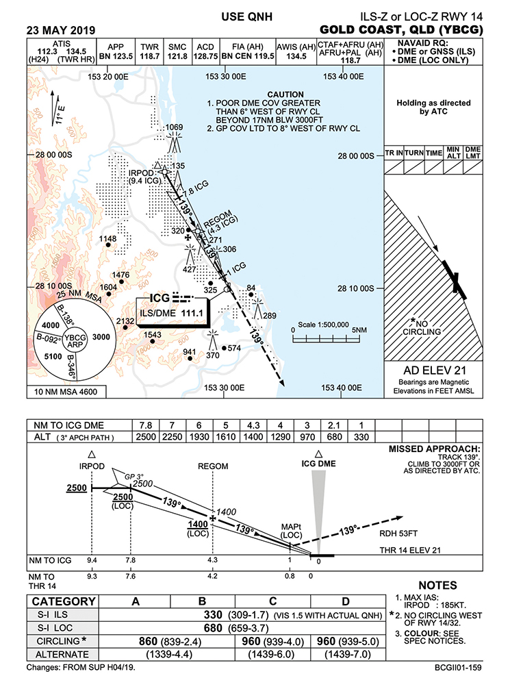
1. Mal is being sequenced behind a 737 which reports being established on the localiser at 15 nm. The 737 has been told to maintain maximum speed by ATC. The maximum IAS at which this Category C 737 could cross the IAF would be?
- 150 knots
- 180 knots
- 185 knots
- 240 knots
2. The minima applicable for Mal’s planned approach on the YBCG ILS RWY 14 is:
- 330 ft/0.8 km if high-intensity approach lighting is available.
- 330 ft/1.7 km with the ATIS QNH and a flight director available.
- 230 ft/1.5 km with all runway edge lights available and actual QNH.
- 230 ft/1.2 km if the approach can be flown with flight directors and autopilot.
3. What recency requirements does Mal need to satisfy to conduct an ILS approach in IMC for a single-pilot operation in this aeroplane (his last instrument proficiency check was 9 months ago)?
- Has conducted a single-pilot IFR flight or simulated flight of at least one hour within the previous 6 months including an instrument approach and conducted a 3D instrument approach within the previous 90 days.
- Has conducted a single-pilot IFR flight or simulated flight of at least one hour within the previous 3 months and conducted a 3D instrument approach within the previous 180 days.
- Has conducted an IFR flight or simulated flight of at least one hour, with any instrument approach, within the previous 180 days.
- Has conducted 3 instrument approaches within the previous 3 months.
4. Mal always prepares himself mentally to consider what he will need to see at the minima to be able to continue to land. If the approach was being conducted during a time where no accurate QNH was available (1.7 km visibility required), at the minima if Mal is on the 3-degree glideslope, he will need to see, at a minimum:
- The HIALS (high-intensity approach lighting)
- The runway threshold only
- The upwind end of the runway
- The PAPI or touchdown zone
5. Mal is informed by ATC on descent that a lighting failure has resulted in the runway edge lights only illuminating every 120 m. Visibility required at the minima for the ILS approach is now:
- 1200 m
- 1500 m
- 2250 m
- 2400 m
6. Some ILS approach charts have a visibility minima of 550 m for CAT 1 approaches. For airports equipped with RVR capability, RVR is reported in the METAR/SPECI whenever the prevailing visibility reduces below:
- 800 m
- 1000 m
- 1500 m
- 2000 m
7. After touchdown, the rate of rainfall increases during the landing roll. By the time the aircraft reaches the upwind end of the runway, the heavy rain combined with the wiper capability results in significantly reduced visibility for Mal looking forward through the windscreen. The runway center line lights indicate Mal is within 300 m of the runway end when:
- White lights become red for the last 900 m
- Alternating white and red lights become red 300 m from the runway end
- White and red lights alternate for the last 300 m
- White lights become yellow for the last 600 m
8. After fueling is completed, taxiing out for departure to YBBN, the wind is now 10 knots from the SE, the visibility reduces significantly in passing showers and the cloud ceiling is 400 feet. All navaids and lighting are operating normally. The minimum visibility required for departure at YBCG is:
- 550 m
- 800 m
- 1500 m
- 2000 m
9. When lining up for departure at the full length of RWY 14, Mal observes he can see along the runway to the point where the runway edge lights change from white to yellow and can see at least 2 of the yellow lights. The length of RWY 14/32 pavement is 2492 m. This would confirm the visibility is at least:
- 1200 m
- 1500 m
- 2000 m
- 2300 m
10. Refer to the following SPECI: SPECI YSSY 052000Z 33006KT 0500 R34L/0600N R34R/1200V1800D FG ////// 16/15 Q1006 RF000.0/000.0
Which statement is correct with regards to the visibility on RWY 34R YSSY?
- TDZ RVR is 1200 m, and 1800m at the mid and upwind end.
- RVR on 34R is 1200 m, with variations to 1800 m at the downwind end.
- RVR on 34R is 1200 m, with variations to 1800 m in the last 10 minutes and is trending down.
- TDZ RVR is 1200 m, with variations to 1800 m in the last 10 minutes.
Answers:
- (c) IAF is IRPOD. Category C initial approach speeds are specified in Part 91 MOS, Table 14.09. Speed limit is in the notes on the chart. however (bottom right).
- (c) Refer to Part 91 MOS 15.10.
- (a) CASR 61.875 (1) (2), 61.870 (5).
- (d) ALT chart: 3 degrees at 1 nm to ICG is 330 feet. ICG DME is at the touchdown point. 1 nm is 1852 m. NM to ICG and NM to the threshold of RWY 14 is 0.2 nm less. Therefore, the 330 ft minima at 1DME ICG is 0.8 nm to the threshold. Being only able to see the threshold would indicate a visibility of 1481 m at this point.
- (c) Part 91 MOS 15.10 (2)(g). Visibility required is 1.5 x 1500 m.
- (c) http://www.bom.gov.au/aviation/data/education/rvr.pdf
- (b) AIP AD 1.1 – 27
- (c) Part 91 MOS 15.03. Not to be confused with 15.05.
- (c) 2492 m – 600 m (yellow lights) = 1892 m + 120 m (2 yellow lights) = ~2000 m vis. AIP AD 1.1-26, 5.4.
- (c) http://www.bom.gov.au/aviation/data/education/rvr.pdf


