
Information in this story has been superseded.
It remains here only in the interests of openness.
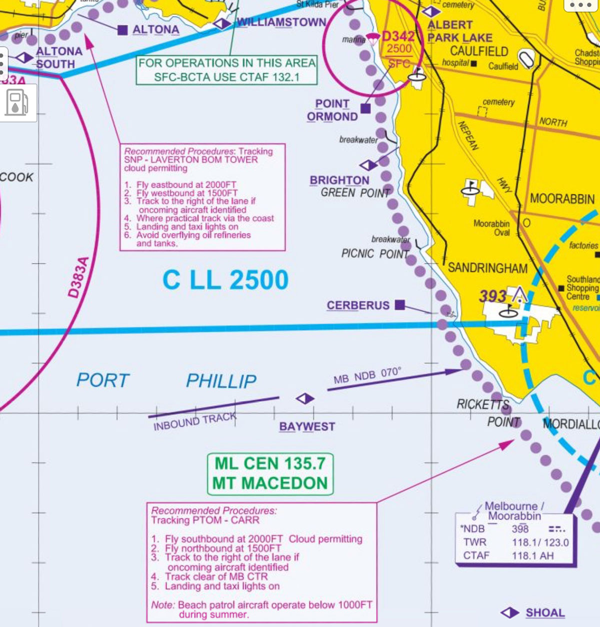
If you fly VFR around Port Phillip Bay, you need to know about airspace changes that come into effect on 8 November.
The changes will see a lowering of Class C airspace from 2500 feet to 2000 feet under the approach and departure path for Runway 34 at Melbourne Airport to accommodate a Category 1 ground-based augmentation system landing system (GLS) approach.
As a result, a change has also been made to the recommended altitudes for VFR pilots flying the coastal route between the Laverton BOM Tower and Carrum, and vice versa.
The new procedure recommends pilots flying eastbound/southbound fly at 2000 feet and westbound/northbound at 1500 feet. You should also track to the right of the lane when approaching aircraft are identified, in accordance with CAR 161 VFR right of way rules.
The VTC aeronautical chart inset 1:150,000 scale has been updated with the new VFR lane procedures.
This is a recommended procedure only – you should check your charts for the most recent information at all times or ensure your electronic flight bag is up to date.
And, to state the obvious for safety’s sake, monitor the appropriate frequency when you fly for traffic information.
Update: This extract from the Melbourne visual terminal chart (VTC) shows the changes. (Only the actual chart should be used for navigation.)


Here comes plenty of VCA’S
Shouldn’t these changes be trumpeted from the tops of the highest buildings? Written in the sky in letters a thousand feet high? Preceded by a focused advertising campaign that runs for several weeks?
Of all the changes imposed on GA, this is one with HUGE potential to cause accidents, and I am reading about it in a routine CASA newsletter ONE WEEK before the proposed change is implemented?
Q. Why is this necessary ? 500′ matters to powered and unpowered low flying aircraft. Is the same necessary for powered approaches?
& Ditto Eric. Seems besurocractic power mongering rather than necessity.
Hey “Staff writers”, how about pictures of the relevant map areas to assist in describing these important new procedures, instead of a photo of a random 172? You know, for FLIGHT SAFETY?
What I find odd is why swap the East / West traffic altitudes with one another just to add to the confusion.
New CLL2000 to allow for YMML ILS approaches from the south
So the notional vertical separation between aircraft will be 2000-1500 = 500 feet. However, a lot of us fly a couple of hundred feet under the controlled airspace figure, to “keep ourselves nice” with ATC. This means say 300 feet separation from northbound traffic.
And what’s the altitude over the Carrum reporting point for aircraft inbound for Moorabbin – 1500 feet? So those of us heading north but not going to Moorabbin can either take our chances at 1700-1800 feet, or go down to say 1200 feet.
Can anyone else see a problem here, or can we all depend upon our skills as precision pilots who never deviates from their set altitude?
But it dose state “recommended” l would prefer to do it at 1000ft north and west and 1500ft east and south.