
Northern Australia is a tempting yet tough environment for aviation, where a scattered population depends on aircraft in the way the people in the southern cities depend on buses and trains. There is also the northern Australian specialty of helicopter mustering.
The constant demand for aviation services makes it a drawcard for young pilots looking to build hours and experience. Some arrive with as little as 200 hours in their logbooks, and little exposure to commercial operations.
Distinctively, and temptingly for the young pilot, VFR charter services form a sizeable proportion of flying hours.
Yet at the same time it is no place for an inexperienced pilot. Thunderstorms, heavy rain and reduced visibility are just some of the hazards that visual flight rules pilots face during a typical wet season in the Top End of Australia.
The hazards are concentrated in the wet season that begins at the start of November and finishes at the end of April. The wet season sees the majority of Darwin’s 1700 mm average rainfall occur. Nearly 1600 mm of Cairn’s 1987 mm annual rainfall happens in the wet with the heavens cascading about 400 mm a month from January to March. (Melbourne’s annual rainfall, for comparison, is about 650 mm) Wet season rains tend to fall in heavy, short bursts which cool and rejuvenate the land and its ecosystems.
Temperatures also increase, typically ranging from a minimum of 25 degrees to a maximum of 33 degrees with increased humidity levels. The build-up months of October and early November are infamous for their combination of heat and humidity.
CASA recently hosted a safety seminar and webinar in Darwin to highlight the features of Top End weather that VFR pilots need to know about.
For the webinar, CASA aviation safety advisor, Tim Penney, was joined by the Bureau of Meteorology forecaster Harry Burns-Fabb and director/instructor Cameron Marchant of local training organisation Flight Standards Darwin.
The trio identified four key aspects of Top End flying in the wet.
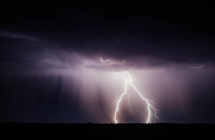
- Thunderstorms
Darwin and the west coast of the Top End see about 80 thunder days every year. During the wet season, the south-eastern airflow that brings dry weather to northern Australia in the ‘winter’ months breaks down, Burns-Fabb says. ‘That allows humidity to build up from the north with the result being thunderstorms, tropical cyclones and associated hazards.’
Thunderstorms become regular in the Top End by November, and daily by late November/early December. Monsoonal conditions and tropical cyclones typically arrive early in the new year, although tropical cyclone season formally runs from November to April.
Thunderstorms rise in the afternoon due to surface heating, which causes heated air to rise from over the ground. This rising air produces cumulus clouds which in the wet season develop into towering cumulus.
Over the sea the development of thunderstorms is reversed. Thunderstorms over the sea are more common in the evening when they develop because of the cooling of cloud tops after sundown. The cooling means the warmer air at the bottom of the cloud rises, creating thunderstorms.
Thunderstorm hazards
When you get thunderstorms, you get precipitation. That brings low visibility conditions and low cloud in the vicinity of the thunderstorm.
Within the thunderstorm there will be strong updrafts and downdrafts. That means severe turbulence and severe windshear, also lightning, which can be very hazardous to aircraft.
What should you do when flying in these conditions? Marchant says to give thunderstorms a wide berth. ‘We have golden rules’ he says. ‘Firstly, if you do have to pass a thunderstorm fly around on the upwind side. To fly on the downwind side exposes you potentially to hail from the storm cell or other adverse effects. If you have to fly downwind because you have no option, you need to double the amount of clearance you had on the upwind side.’
He also says to never try to fly under a thunderstorm to pass it. That’s where the downdrafts and microbursts are.
- Microbursts
A microburst typically happens when there’s a little bit more dry air below the thunderstorm, Burns-Fabb says. ‘When the precipitation falls into this dryer air it evaporates. This evaporation causes cooling in the atmosphere which causes acceleration towards the surface.’
When a microburst reaches the surface, it spreads out. This can cause turbulence and windshear. ‘We’ve recorded wind gusts of over 100 knots in microbursts.’
- Lightning
Most people closely associate lightning with thunderstorms, but a giant storm of the Top End can cast lightning into clear air. ‘Aircraft have been struck up to 20 nm from a thunderstorm,’ Burns-Fabb says.
- Pressure, atmospheric and human
The interaction of weather and commercial factors with a typical Top End flight profile can cause ‘pressure points’ for a pilot of any experience, Marchant says. ‘The way to fly safely is to have techniques at hand for dealing with these pressures.’
‘A pilot contemplating a departure needs to analyse the weather,’ he says. ‘Low altitude in the take-off and climb-out phase of flight makes an aircraft particularly vulnerable to thunderstorms microbursts.’
Marchant cautions against using special VFR, as a flight planning tool for normal operations in dubious weather. ‘Special VFR can be misconstrued as a tool for planning departures from a controlled aerodrome. We would generally discourage that concept,’ he says. ‘To plan to use special VFR is simply to erode the margins.’
He notes that ATC will not prioritise a special VFR flight over normal IFR flight. ‘A special VFR flight could find itself painted into a corner with few options.’
Instead he recommends two strategies: waiting and carrying more fuel. ‘With time and fuel most problems can be managed. A good strategy is to carry an amount of fuel that will allow you to wait out the weather as it passes your destination aerodrome.’
Managing customer expectations
Young or newly qualified pilots coming to the Top End to build hours are often inexperienced in customer service, Marchant says.
Charter flying is as much a customer service activity as an aviation activity he says. ‘For sure, the technical flying of the aircraft is important, but generally speaking the passengers will have some sort of imperative that they will have to get to a meeting, a task or similar.’
‘What a young commercial pilot has to do if confronted by inclement weather is explain. Generally, if you can’t provide a customer with what they want, you need to provide them with a reason why that’s the case and a logical solution, or alternative. It might be a delayed departure, by an hour or two. Or you might offer to reschedule the flight for another day.’
‘Most people, although uninformed of the technicalities of the weather, only have to look into the sky to see the severity of the storms and most people are risk averse,’ Marchant says.
Convective turbulence
This form of turbulence is caused by the sun heating the ground and causing warm air to rise. The turbulence happens when the rising air clashes with the air around it. Convective turbulence is present in thunderstorms but can also occur in clear air at low altitudes.
‘Rule number one about turbulence is to avoid it,’ says Marchant. ‘It’s a common practice among IFR pilots to fly around clouds. You often hear them talking about deviations left and right. They are doing that to avoid entering cloud which will create turbulence.’
A fundamental reason to avoid turbulence is to keep the aircraft’s load factors within limits. ‘By load factor we are talking about the amount of aerodynamic stress the airframe is designed to withstand. The typical normal category aircraft, has a load factor of 3.8.G and half that in negative G. In turbulence with bumps and stresses on the airframe these can be exceeded,’ Marchant says.
Aerodynamic loads are exaggerated or increased by aircraft speed. Manufacturers publish a manoeuvring speed or turbulence penetration speed, the speed at which the aircraft needs to be flown at or below in order to avoid the loads on the airframe becoming excessive.
The limits of forecasts
‘I’d love to say we get it right 100 per cent of the time, but sometimes we get it wrong,’ Burns-Fabb says. ‘The forecast is our best guess, and there are a lot of steps in producing it, such as a massive amount of data, observations, numerical prediction, and using our scientific understanding of the broad scale atmosphere and adding local effects. The sea breeze in Darwin for example has huge implications.’
‘A difference in a sea breeze of 2 or 3 knots can be the difference between a thunderstorm developing or not.’
‘If our best guess changes we’ll amend the forecast as soon as we can,’ Burns-Fabb says.
The implication for pilots is to always remember that it is possible the weather will be more severe than forecasted. Darwin’s ATC also relies on the Bureau of Meteorology’s weather information and has no dedicated facilities.
‘If you see weather that was not forecast give us a call, let us know,’ Burns-Fabb says.
Finally, Burns-Fabb emphasises that the Bureau of Meteorology’s website is an educational resource for pilots. ‘On our BoM website we have a knowledge centre, with a vast array of knowledge on various topics, thunderstorms, wet season weather etc. We list our phone numbers on the bottom of graphical area forecasts. If you have any questions about interpreting the forecasts give us a call.’

Thank you for this informative article.
[…] with the distinctive and dangerous weather of Australia’s Top End led to an in-flight break-up that killed two pilots, the Australian Transport Safety Bureau (ATSB) […]
Very good, some piece of information very useful in many situations I’ve faced before when flying over the Amazon in Brazil. Thanks