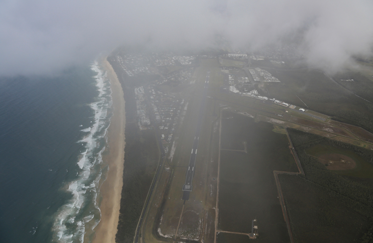
Scud running implies an intentionally hazardous flirtation with visual flight in near (or actual) instrument meteorological conditions (IMC), a clear no-go. But what of the risks of legal flight in marginal VFR conditions?
Marginal VFR weather in most airspace is ceilings as low as 1000 feet and/or visibility as low as 5000 metres. Few pilots routinely fly VFR in this kind of weather, so let’s consider go/no-go decision-making when faced with these conditions. (By day, when VMC does not exist, ATC may issue a special VFR clearance, provided the flight is conducted clear of cloud and visibility is not less than 1600 metres for an aeroplane and 800 metres for a helicopter.)
Risk management
How can you avoid becoming a marginal-weather statistic?
- Know what marginal VFR looks like. Most flight instruction takes place in excellent weather. Almost no one trains for it before actually trying it alone. The next time the ceiling hovers around 1500 feet or the visibility is about 10 kilometres, hire an instructor for a VFR flight, including landing on at least one airfield other than your home base. Your instructor should be extremely familiar with the area’s obstructions and serve as an extra set of hands and eyes in the cockpit. Even your home aerodrome will look different from low altitude or in marginal weather. You’ll be amazed at the increase in workload and anxiety brought on by a loss of normal visual cues and you’ll gain a healthy respect for the risks of marginal VFR flight.
You’ll be amazed at the increase in workload and anxiety brought on by a loss of normal visual cues.
- Know where you’re going. Safe flight in marginal conditions demands thorough pre-flight planning of your route and where you’ll go if your primary route is closed off by weather. GPS may be more limited than you’d think. Unless you keep your GPS database updated, it may not warn of new obstacles along your route. Follow highways or railways and other prominent landmarks to crosscheck the moving map. Keep the nearest airfield in mind at all times, making a new go/no-go decision each time you pass another runway. Review landmarks near your destination so you can find it in the murk.
- Define minimum altitudes. Plot the minimum safe altitude for each segment of your flight: at least 1000 feet above the highest obstacle within 10 nm, except as otherwise permitted by CASA. Write these minimum heights on your chart (using notes on electronic charts) so you’ll have the information when you need it. If you have to descend below that altitude to maintain cloud clearance, divert immediately. It’s far easier if you’ve made this decision beforehand.
- Slow down. It takes the average human about 10 seconds to visually acquire a conflict, recognise it as a threat, decide to take evasive action and make a control movement to avoid the obstacle. It takes the aeroplane one to two more seconds to respond. In the average 12 seconds it takes to detect and manoeuvre around an object, flying at 90 knots ground speed, covers about 500 m/0.3 nm. At 120 knots, you’ll fly 600 m/0.4 nm; at 150 knots, you’ll cover 800 m/0.5 nm. At 180 knots ground speed, you’ll fly 0.6 nm or just more than one kilometre in this decision-making time. Slow down! Fly at the speed you use for downwind in the circuit. The slower you’re flying, the better able you’ll be to see and avoid a threat. Lowering flap will give better forward visibility.
- Use your autopilot. An autopilot, if you have one, is one of your best tools. As pilot monitoring the autopilot, you have more bandwidth to address navigation and obstacle avoidance.
- Plan your escape. You have specific altitude and visibility criteria to meet at all times. (Refer VFRG). If it appears you may soon violate any of these criteria, execute your escape at once. Do not wait to decide. It will not get better a little further along.
The classic fix is a 180-degree turn. Here too, you’ll find a big advantage in slowing down. In zero wind and at 90 knots ground speed, the diameter of a 180-degree turn (assuming three degrees per second, or a standard rate) is about 1.6 km/0.9 nm—you will be displaced by that distance from your original ground track when you roll out on the reciprocal course.
Flying at 120 knots, you’ll be 2 km/1.2 nm off ground track, while 150 knots yields 2.6 km/1.5 nm off the path you used to enter. You may not see obstacles on your escape route until you’re established in your turn. You may use steeper banks, but they present their own hazards in marginal VFR.
If you’re in trouble, it’s time to contact air traffic control and get help to land safely.
- Know your limitations. Research reveals pilots without instrument training typically lose control of the airplane about 180 seconds after entering IMC. What better reason to get some instrument instruction, even if you never plan to earn the rating? Make it pertinent by concentrating on the level, 180-degree turn and other survival manoeuvres.
It’s not the weather itself that causes accidents—it’s the way we make decisions about flying in weather.
For further reading: flightsafetyaustralia.com/2018/12/big-trip-weather-planning/


Familiar text but always worth repeating. Usually, marginal weather is encountered en-route. This is where your decision making becomes important. There is no reason not to land at the nearest available to wait it out, re-plan or just regain composure.
I wish pilots could be educated in the first line of defence: ALWAYS MAINTAIN A CLEAR HORIZON. Simple. It works.
Great article, sitting in my office at home it seems so common sense. However how quickly can it can all go out of the door when in the air, workload increasing and the weather is ominously closing in. If I find myself starting to see things not progressing as planned or approaching my comfort/ skill level I consciously make a decision to go way back to basics of airmanship and all that this entails. Hasn’t failed me so far.