
The tiniest change of heading took this pilot out of his comfort zone.
As a low-hours VFR-only recreational pilot who is super safety conscious, I have always considered close calls not just as near misses regarding accidents, but also as near misses regarding safety margins or personal safety comfort zones. It is against that background I tell this story.
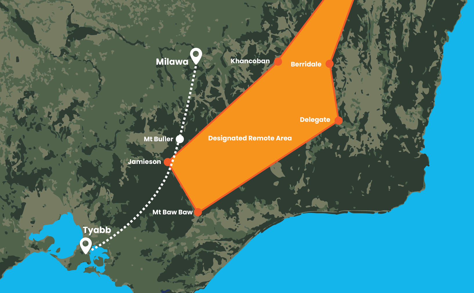
My wife and I decided to make yet another flight to our favourite winery, Brown Brothers at Milawa, Victoria. The winery has its own well-kept grass airstrip and a nice restaurant in pleasant surroundings. The winery is about an 80-minute fight in a C172 from our home base, Tyabb, Victoria.
The direct route from Tyabb to Milawa runs north-north-east. To the left of this route, our usual choice, is low flat ground and a series of small airstrips useful for emergency purposes. To the right of the direct route is the start of the Victorian Alps leading up to the Snowy Mountains and Australia’s highest peak, Mt Kosciuszko in NSW.
We like flying over mountains so, on this occasion for a bit of variety, I decided to fly a route a little right of the direct route. This would take us over the western end of the Great Dividing Range and over the top of Mt Buller and the alpine village which are at a height of almost 6,000 feet.
With the forecast weather and clouds OK, I decided to cross Mt Buller at 9,500 feet. This met the hemispherical rule for cruising altitudes and kept us sufficiently clear of terrain and clouds. It also kept us under 10,000 feet, the maximum I am allowed with my Basic Class 2 medical certificate.
After departing Tyabb, we flew east to avoid the Moorabbin Airport training area and the parachute drops over Tooradin Airport, and turned north-north-east, which took us a little to the right of the direct route.
Later, with Mt Buller directly ahead but still a way off, it looked like the clouds were noticeably lower than forecast. I considered crossing Mt Buller at the lower altitude of 7,500 but was concerned that the clearance from terrain would be much less. Also, the gliding distance to the eastern low, flat ground, with its numerous emergency airstrips, would be greatly reduced.
To add to my already racing mind, it suddenly dawned on me that I had not factored in the officially Designated Remote Area to my planning! We may well be over it now, in which case we were supposed to be carrying emergency supplies, which we weren’t.
I began explaining to my wife why we might need to turn west to pick up our normal route and, even before I finished, she said, ‘Well, what are you waiting for?’ It wasn’t a question, more like an instruction!
I like flying with my wife because she enjoys it and, like me, is super safety conscious, and a great reminder of checklist items such as transponder on, correct frequency, eyes down the end of the runway when landing. She is also very decisive!
We turned west and the rest of the flight was uneventful and enjoyable. But at the time, I felt that continuing as originally planned might be jeopardising safety margins. As my mind was racing and I was sweating a little, I felt I might be leaving my personal safety comfort zone.
After landing and checking the Designated Remote Area, which unfortunately is not marked on the aeronautical chart, I discovered that, sure enough, I had incorrectly flown into it for a distance of about 20 nm.
Lessons learnt
I follow accident investigations and close calls and learn much from them. There are too many accidents and some have been too close to home, involving people in my own flying club.
Although there was no near-accident close call involved here, there was clearly a case of a close call regarding safety margins and personal safety comfort zones. I prefer the latter close call to the former!
I was pleased with the action I took and in particular, that I did not succumb to the dangerous ‘get-there-itis’.
Flight planning is one of the special topics on our Pilot safety hub.
Have you had a close call?
8 in 10 pilots say they learn best from other pilots and your narrow escape can be a valuable lesson.
We invite you to share your experience to help us improve aviation safety, whatever your role.
Find out more and share your close call here.
Disclaimer
Close calls are contributed by readers like you. They are someone’s account of a real-life experience. We publish close calls so others can learn positive lessons from their stories, and to stimulate discussion. We do our best to verify the information but cannot guarantee it is free of mistakes or errors.


Comments are closed.