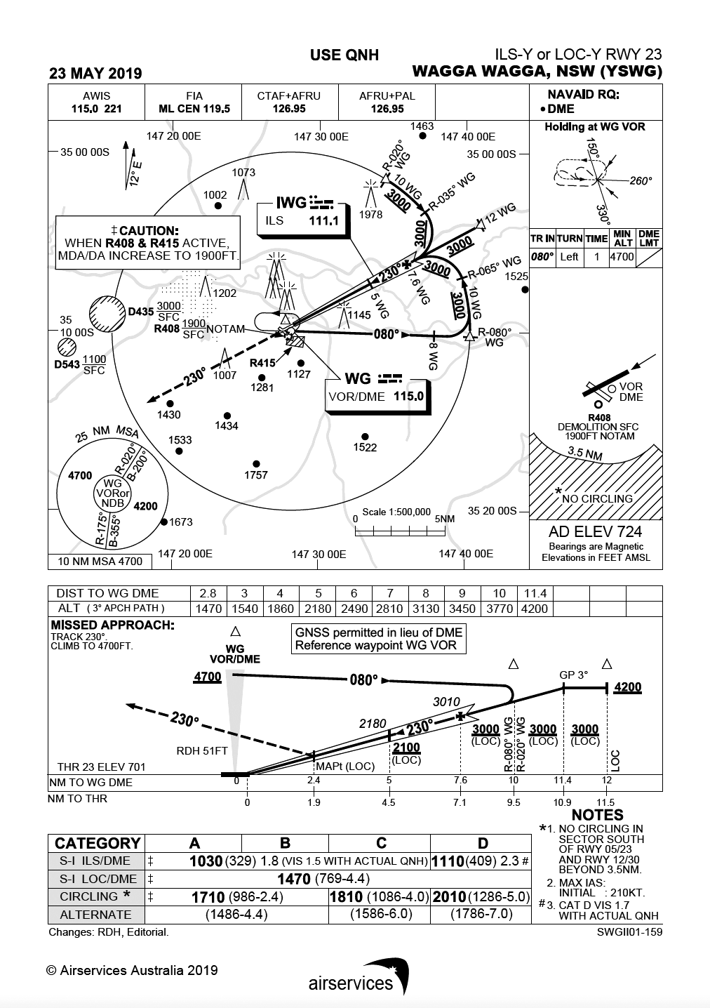
 Refer to the YSWG ILS-Y 23 approach chart.
1 You are currently tracking inbound on the 080°R WG VOR. Your GPS shows a distance of 20 nm. You are at 6000 ft and intend to join the ILS inbound on the 050°R at 3000 ft. Assuming that you intend to descend while on the arc at a steady 500ft/min with a groundspeed of 120 knots, what is your TOD point from the WG VOR?
- 10 nm
- 17 nm
- 13 nm
- 20 nm.
Refer to the YSWG ILS-Y 23 approach chart. You are currently planning a flight into YSWG and intending to conduct the ILS-Y 23 Approach as a CAT B aircraft.
- TAF YSWG 222237Z 2300/2312
- 25030KT 4000 RA BKN015 FEW010
- BECMG 231000 23010KT 9000 BKN050
- T 20 18 16 16 Q 1013 1013 1010 1011
2 For a planned ETA of 0900Z at YSWG, are you required to plan an alternate? What would it be if you were operating a CAT C aircraft?
- There is no operational requirement to plan for an alternate as the conditions dictate they are above the alternate minima for CAT B.
- An alternate aerodrome needs to be planned as the cloud and visibility are less than the alternate minima.
- An alternate needs to be planned for a CAT C as both the cloud base and visibility is below the specified alternate criteria.
- Both a and c are correct.
3 Referring back to the above TAF. Assuming your planned ETA was still 0900Z and you wish to consider not planning for an alternate and instead to hold overhead. For a CAT C aircraft, how many minutes of holding fuel are you required to have on board until the conditions improve and what time does the operational requirement cease?
- 90 minutes holding fuel and 1030Z
- 60 minutes holding fuel and 1000Z
- 30 minutes holding fuel and 1030Z
- 30 minutes holding fuel and 1000Z.
4 You are planning an IFR flight and consider flying the published one-way route in the opposite direction. Are you able to initiate this flight on that given route?
- Under no given circumstances are you legally able to fly against a published one-way route.
- Flight initiated on a one-way route in the opposite direction is permitted subject to the pilot’s discretion and taking all necessary actions to ensure no traffic conflict.
- You are not approved to fly in the opposite direction in controlled airspace; however, these restrictions do not apply when operating in Class G airspace.
- You may plan to fly the route with that restriction subject to ATC approval, but it may not be available. These restrictions do not apply when operating in Class G airspace.
5 You are approaching controlled airspace but the approach controller has advised you to remain clear of controlled airspace. You are flying in IMC and decide to hold at a non‑published holding waypoint. You plan to make the inbound leg of the hold as 152°M and are currently tracking towards the hold on 322°M, with the heading of 342°M towards the fix. Assuming you are carrying out a standard holding pattern join, what is the sector entry?
- direct entry
- offset entry
- parallel entry
- you advise ATC of your intentions and initiate the offset entry.
6 You are established in the holding pattern at 8000 ft overhead the field when ATC advises the airport has temporarily closed due to an aircraft incident on the runway. As ATC are uncertain how long this temporarily closure will be, they ask how long you can hold overhead before you track to your alternate aerodrome. Your aircraft has 176L on board with a normal cruise consumption rate of 80L/hr. Considering 30 minutes alternate fuel, 45 minutes fixed reserves, six minutes approach fuel, three minutes for taxi, and basing these consumption rates as normal cruise, how many minutes can you hold overhead and how many laps of the hold can you expect to complete?
- 60 minutes holding fuel and 15 laps
- 48 minutes holding fuel and 12 laps
- 24 minutes holding fuel and 6 laps
- 52 minutes holding fuel and 13 laps.
7 Refer to both YSCB ILS-Y & ILS-Z approach chart. You intend to conduct the Canberra (YSCB) ILS approach runway 35; however, you are unsure what approach chart to use as they have both ILS-Y and ILS-Z. Apart from the aircraft being equipped with an ILS, it also has a standard TSO-145 GPS. What approach chart should you use to conduct the ILS?
- ILS-Y approach chart should be used, based on conventional ground-based navaids
- ILS-Z approach chart should be used, based on the aircraft being equipped with a certified GPS
- ILS-Y approach chart should be used, based on the aircraft being equipped with a certified GPS
- ILS-Z approach chart should be used, based on conventional ground-based navaids.
8 You’ve recently bought an aircraft and are intending to upgrade it to IFR in order to conduct charter operations. What are the minimum radio navigation systems required to be fitted for the aircraft to operate in the charter category?
- Two GNSS units certified TSO-C145 or higher and either one ADF or VOR airborne aid
- One GNSS unit certified TSO-C129 or higher and either one ADF or VOR airborne aid
- One ADF and one VOR unit, with the additional of one multi-sensor navigation system that includes GNSS and inertial integration
- Two GNSS units certified as TSO-C129 or higher.
Answers:
1 (b) Height to lose 3000 ft. Descending at 500 ft/min is six minutes. Because you are intending to cross 30 degrees of radials while on the arc, you need to convert the degrees into arc miles. Rule: On a 10‑mile arc, for every six degrees of radials crossed, you have travelled one mile. Therefore, you would have travelled 5 nm after 30° radials. With a ground speed of 120 knots, therefore 2 nm/minute; your TOD point will be 17 nm from the WG VOR aid.
2 (d) Reference AIP ENR 1.1 Para 11.7.2.1
3 (a) Reference AIP ENR 1.1 Para 11.7.2.7
4 (d) Reference AIP GEN 3.2 Para 2.1.2 ENR 1.7 Para 3.1.3
5 (c) Reference AIP ENR 1.5 Para 3.4.1 Assuming it is a standard holding pattern, it will be a right-hand holding pattern (ENR 1.5 para 3.1.3). As mentioned, the inbound leg of the hold is the 152, with the aircraft tracking to the fix on the 322. Note: determination of the sector entry is based on aircraft heading not track to the fix. Therefore, the parallel entry (sector one) is the appropriate joining procedure.
6 (b) Converting the remaining fuel on board—176L—into minutes at the cruise consumption rate of 80L/hr, we have 132 minutes of fuel on board. After subtracting 30 minutes alternate fuel, 45 minutes fixed reserve, six minutes approach fuel and three minutes taxi fuel from 132 minutes, the fuel remaining for holding overhead is 48 minutes. Assuming that each lap of the hold takes four minutes, we can expect to complete 12 laps in the hold.
7 (c) ILS-Y approach plate should be used as the aircraft is not equipped with any other ground-based navaids for distance reference i.e. DME equipment. Instead, since the aircraft has an approved GPS, it can be used for distance reference so long it is correctly set-up for the nominated reference waypoint. This is indicated by a box around it, stating ‘GNSS permitted in lieu of DME Reference waypoint CB VOR’.
8 (b) Refer AIP GEN 1.5 Para 2.1


Q 1 You are currently tracking inbound on the 080°R WG VOR.
Comment. Either I am confused OR in tracking to the VOR on the 080 Radial no descent should be made until passing the VOR overhead and positioning to track OUTBOUND on the 080 Radial commencing the approach and then not below 4700′ until past the Vor and on the approach. Personally to avoid any possible conflict I would remain at 6000′ until over the VOR commencing the approach and then the caculation as made in the answer would apply.
Or did I miss something?
Yes, you are tracking inbound on the 080°R WG VOR; but you are still well outside the 10 DME arc, and well-positioned to intercept the arc at the IAF marked ‘R-080 WG’; at which point you can turn inbound on the arc (not below 4200 AMSL). I think this is the approach the questioner has in mind, and is certainly more efficient than tracking all the way to the VOR, then outbound again and then joining the same arc.
Edit: sorry – that should be not below 3000 AMSL at the R-080 WG IAF (not 4200). Though 4200 would, of course, be the 25NM MSA in that sector until reaching the IAF.
Q 2. The visibility given on the TAF is 4000m; the alternate minimum for Category B is given as 4.4km.
As I see it, ‘c’ is certainly correct; ‘a’ (and therefore ‘d’) is certainly incorrect. ‘b’ is broadly speaking correct, though not strictly correct as it is only the visibility that is below minimum for Cat B, not cloud.
What am I missing?
Question 2. I read the alternate minimum visibility for CATB to be 4.4 K. The TAF indicates 4000m and not improving until 1000Z. My reading a CATB aircraft would require an alternate or 90 mins holding.
Question 8. Would you not need a TSO 145 or higher receiver to meet the ADSB requirements?
From the text
“Answers:
2 (d) Reference AIP ENR 1.1 Para 11.7.2.1″
I suggest the the published answer (d) is the wrong answer. As you say James,”‘a’ (and therefore ‘d’) is certainly incorrect”,
I also would suggest we highlight the fact that any element of the forecast which is below the alternate minimum calls for an alternate or holding to be allowed for. I think (b) would have been better worded if reference to the cloud forecast had been omitted.