
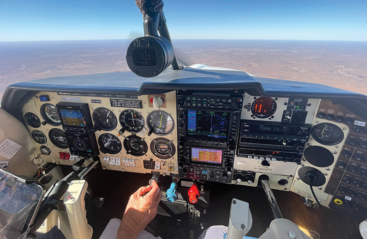
We’re tracking across the Nullarbor today. Maybe you’re asking ‘why’? Well, for starters, good luck with keeping the marriage or the mateship intact if you’re taking on that endless strip of bitumen on 4 wheels. However, you’ve drained your bank balance and half your brain cells getting your pilot’s licence, so you may as well put it to good use.
This massive, treeless stretch of country has always fascinated me. The Nullarbor is bordered to the north by the remote and inhospitable Great Victoria Desert and to the south by the Great Australian Bight. I always reckon the bight is well named. It’s like the 8 million square miles of Southern Ocean has come roaring up from Antarctica and hurled itself full bore at the coastline, taking a massive bite out of Australia.
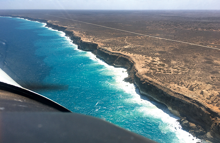
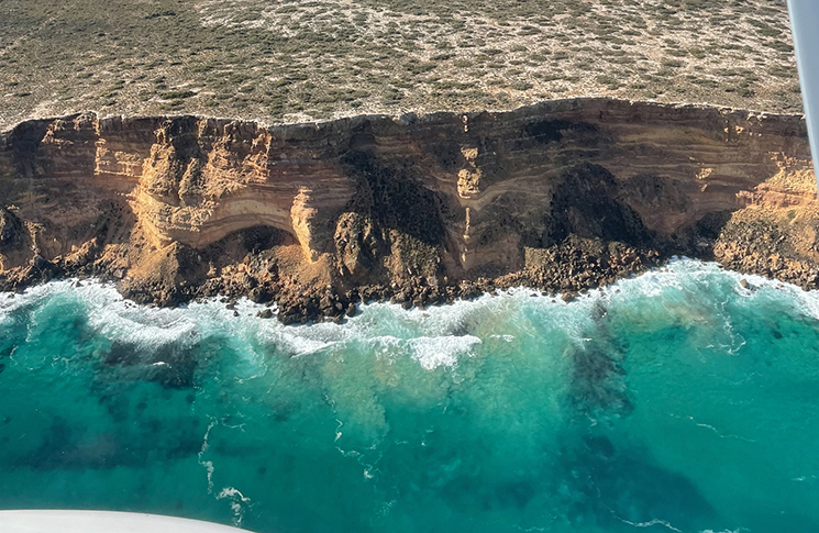
The undisputed show pony of this aquatic carnage is the Bunda Cliffs. In a pilot’s world, I throw this one straight into bucket list territory. This approximately 100-kilometre-long stretch of fossiliferous limestone cliffs, rising 60 to 120 metres above sea level, is the world’s longest uninterrupted line of sea cliffs.
A flight along these remarkable limestone beauties is about as memorable and dramatic as you can get.
While the Nullarbor Plain may look like flat and easy terrain to navigate, civilisation gets pretty sketchy down here, so there are a whole lot of things for us to consider.
The stats
First, a few stats:
- Distance: 3,700 nm (round trip)
- Hours flown: 28.2
- Aircraft: Kate’s Mooney M20J
- Performance: 150 KTAS, fuel flow 48l/h
Westbound route
- Day 1 Mudgee – Wentworth (refuel, overnight)
- Day 2 Wentworth – Streaky Bay (overnight)
- Day 3 Streaky Bay – Ceduna (refuel) – Nullarbor Motel (burger) – Forrest (refuel, overnight)
- Day 4 Forrest – Esperance (refuel, overnight)
- Day 5 Esperance – The Lily (coffee) – Busselton
Let’s get going
Unless you live in Forrest, crossing the Nullarbor is going to be bookended with flying legs from your home base. All the usual planning tips and attention to detail – your currency, the aircraft’s MR hours, fuel availability, beds, remote area survival kit and, critically, weather – need to be considered for the entire trip. But it’s the Nullarbor Plain that is front and centre today.
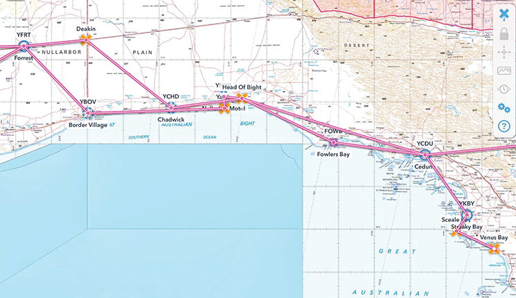
This will be easier with an example, so we’ll retrace the planning involved in a trip we did recently across the country from Mudgee (near Sydney) to Busselton (near Perth), and back. We had a date with about 150 other women pilots at our annual conference over there so my mate Kate and I figured it’d be poor form to go by bus.
A huge map of Australia on my wall at home makes it easy to eyeball a wide route like this and divide it into manageable legs. Do you have a date commitment at the other end? OK, you need to work back from that. How many days do you need to fly across the country? What’s your daily flying limit to keep this comfortable? You may be a pilot who enjoys 6 hours a day in the cockpit – I am not.
Now, your list of non-negotiables. These comprise fuel stops and booked accommodation. Next, the waypoints, regions and experiences en route that you are determined not to miss. Heading west, ours were an overnight stay at Forrest (Nullarbor headquarters), a flight past Venus Bay on the north-west coast of the Eyre Peninsula, a slow cruise along the Bunda Cliffs and a few orbits of Lucky Bay, WA. When it comes to jaw-dropping scenery, these last few live on the top podium.
Ceduna
If you’re flying east to west, let’s say you’ve got yourself to Ceduna on the south coast of SA. This is a great place to stop for either an overnight stay or just refuelling and a leg stretch. Air transport, medivac and charter aircraft may join you in the circuit so listen out on the CTAF from at least 10 minutes out to hear what’s going on. Phone for the AWIS early so you can plan your arrival.
Things can often get pretty breezy at Ceduna. We’ve used the natural-surface cross strip 17/35 almost as often as the main strip and always found it perfectly maintained. With access via the very handy taxiway B, it’s a godsend.
Head of the Bight
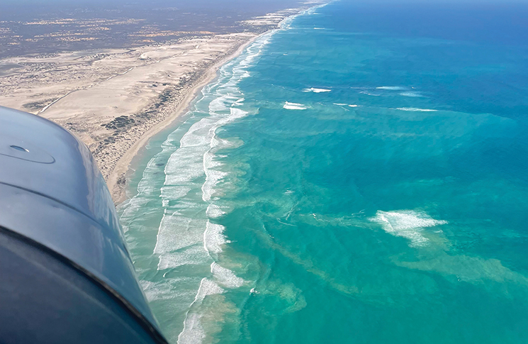
OK, we’ve topped up with fuel, been fed and watered, so off we go, tracking west, and now headed for the main event. Track coastal from Ceduna and you’ll be overflying 50 nm of untouched bays and beaches on the way around to Head of the Bight. Stunning, but here’s a heads-up – be alert for unexpected weather events.
One year, after departing Ceduna in calm and sunny conditions, we flew coastal, only to encounter deteriorating visibility after a few miles. Surprising, given the CAVOK forecast. It turned out to be a dense rolling sea fog on the bight, moving north across the coastline. Be flexible, be prepared to turn around.
Fly neighbourly
Being a significant calving and nursery ground for Southern Right Whales, the Head of Bight gives us an extraordinary opportunity for whale watching. A big reminder about the Fly neighbourly (FN) advice we must follow. Read and absorb the procedures to be followed in the Gen – SP (Special Procedures) section at the back of the ERSA. It’s at FN 4 – HEAD OF BIGHT and is applicable 1 May to 31 October annually. The rules are in place to avoid disturbance to the whales and to land-based whale watchers.
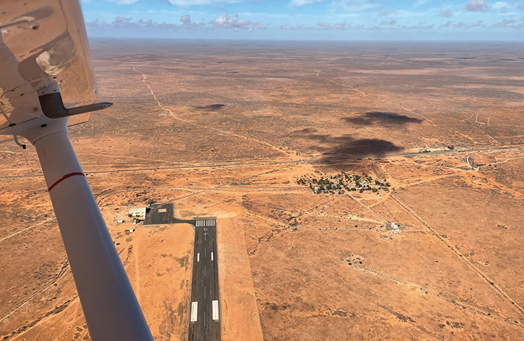
We’re overnighting at Forrest, so let’s plan to land at Nullarbor Motel Airport, just coz we can, and it’s hilarious. The big dirt runway 10/28 stands out for miles. So does the line of road trains and caravans also pulling in for a burger. The airport is remote, so the fuel here is expensive. Otherwise, refuelling at Ceduna or Forrest are good options. But before you turn your back on the bowser here, do your sums, look at any headwind and make sure you can comfortably reach your next fuel stop.
You’ve got company!
From the roadhouse, the Bunda Cliffs run all the way to the WA border, about 55 nm of dress circle viewing. I recommend you slow down and take your time. Choose a height you’re comfortable with; the cliffs are 200–400 feet high. Just remember that everyone else is here to look at the whales and the cliffs too!
A flight along these remarkable limestone beauties is about as memorable and dramatic as you can get.
There’ll likely be other aircraft flying east or west along this coastline, at random levels, so monitor the Nullarbor Motel’s CTAF 126.7 and Melbourne Centre 132.7 if you have 2 radios. Broadcast your type, position, altitude and intentions clearly, listen carefully for other traffic and arrange separation as necessary. About 38 nm west of Nullarbor Motel, see if you can spot the piano keys of the RFDS emergency strip painted on the Eyre Highway.
Heads up, this is remote. Depending on your altitude, expect to lose comms with Centre at some stage along this southern coastline. If you’re cruising at 1,000 feet, you can be guaranteed a decent stretch of radio silence. Should you need assistance, a broadcast call on the CTAF should rally any surrounding crews flying higher, to relay a message to ATC for you. If you’re equipped with an HF radio, go to the top of the class.
We usually follow the coast to Border Village, then turn inland towards Forrest Airport. Don’t even think about crossing the Nullarbor without stopping here for a night. Forrest is one of the last surviving railway townships on the ribbon of steel that is the Transcontinental Railway, stretching 1,700 km from Kalgoorlie to Port Augusta. The managers are awesome; they will spoil you with true outback hospitality, hangar your aircraft and make you wish you could stop the clock, get off the merry-go-round and just stay put.
From here, you can choose to follow the railway line to Kalgoorlie (need a LAME?) or track south back to the coast and head to Esperance. This south-west pocket of Australia is notorious for attracting windy, wet, cold fronts so take great care assessing the weather.
Once again, big mileages here between fuel stops, lots of remote flying. Keep your eyes open for dust storms – rarely forecast, always a possibility. Never assume fuel is available where published, always ring first. To the east of the Nullarbor, there’s a large area of potentially restricted military airspace around Woomera. Read your NOTAMs, plan your route accordingly.
The return route
Time to head home; here’s the route we chose:
- Day 1 Busselton – Kalgoorlie (refuel, lunch) – Forrest (refuel, overnight)
- Day 2 Forrest – Ceduna (refuel, lunch) – Rawnsley Park (2 nights)
- Day 4 Rawnsley Park – Broken Hill (refuel, lunch) – Bindara Station (overnight)
- Day 5 Bindara – Mudgee
Time zones
In Australia, tracking east across vast distances generates a little folder of maths homework for us to do. New state, new time zone. It’s okay heading west but planning Forrest (WA) to Rawnsley Park (SA) via Ceduna on day 2 of our return journey, we needed to factor in losing an hour and a half at the WA/SA border. So, we nominated an ideal (local CST) landing time at Rawnsley, worked backwards using ultra-conservative flying and refuelling times, and ended up with the latest we could depart Forrest (in local WST). Just don’t mix up your time zones! Fading golden hues at sunset are great for a gin and tonic moment, not an unexpected night landing.
SARTIME
Common sense says to always submit a flight plan out here. But think about why you’re including a SARTIME. The way I see it, it’s because you’d like someone to come looking for you if you haven’t turned up at your destination.
Let’s take the dark road here and presume you’ve crashed or had to make a forced landing somewhere. In either case, you’d be pretty keen to see the cavalry arrive overhead or trundling through the scrub in a couple of 4WDs to lend a hand, right? And you’d love that to be as soon as possible after your misadventure.
So, although there’s a popular train of thought to select a SARTIME well after your proposed ETA, it’s not all that smart. Think about how long it might take someone to find you, and that’s after they’ve waited for your SARTIME to expire. Why not choose a time that doesn’t put any pressure on your landing, and set an alarm 5 minutes before your SARTIME to remind you to call them? CASA tells us this all the time; I’m just nagging you to do it. Use my reminder if you like: seatbelt/SAR. I cannot undo my seatbelt until I’ve cancelled my SAR.
Build flexibility into your plan in case of delays due to your health or weather or aircraft unserviceability. Ask yourself what will be the implications of a few days’ delay getter there or getting home – time pressures can lead to poor decision-making.
Crossing the Nullarbor is a journey worth the time and effort to plan carefully. But it’s a treat not to be wasted on just anybody. Take someone you really like. And when you’re lined up with a coastline full of those limestone cliffs, crashing surf and tumbling rockfalls, glance over at your passenger.
They’ll be glad they came.
Further reading
Get a copy of CASA’s Flight planning kit.
It helps low-hour VFR pilots consider what to keep in mind when planning a flight.
It’s the ideal resource to help you develop good flight planning habits.


